The explorers who mapped a nation
Mapping techniques and technologies are vital in understanding America’s geography and cultural history. Traditional hand mapping, photogrammetry, and GIS technology reveal the land’s stories and changes over time. The cultural implications of mapping highlight the importance of representing diverse identities, especially regarding Indigenous peoples. Modern tools like satellite imagery and mobile mapping allow for more accurate and inclusive representations of regions and communities, enhancing our understanding of complex cultural landscapes.
Mapping is more than just a technique—it’s a powerful lens through which we see history unfolding. What’s hidden beneath America’s soil might surprise you. Let’s explore!
The significance of mapping in American history
The significance of mapping in American history is huge. Maps have shaped how we see and understand our land. From early explorers to modern times, they tell stories of discovery. Each line on a map represents an adventure. They also show changes over time.
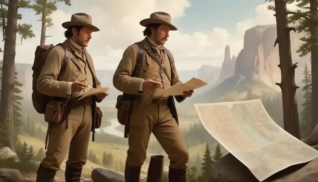
Maps as Tools for Exploration
Early explorers used maps to navigate unknown territories. These maps guided them across rivers and mountains, showing what lay ahead. They captured both the land and the history. Without maps, exploration would have been much harder.
Understanding Boundaries and Ownership
Mapping has also helped define boundaries. It shows where one state ends and another begins. This is important for laws, culture, and identity. Clear maps help avoid confusion and conflicts.
Connecting People and Cultures
Maps connect diverse cultures within America. They show how different groups lived and interacted. Through maps, we learn about ancient trails and trade routes used by Native Americans. They remind us of the rich history we share.
Technological Advances in Mapping
With technology, mapping has evolved. Today, we use GPS and digital maps. These tools make navigation easy for everyone. They allow us to explore in ways that were once impossible.
In summary, mapping plays a vital role in understanding America. It combines adventure, technology, and culture. Maps not only help us find our way, but they also open a window into our past.
Key explorers and their contributions
Key explorers have shaped the story of America. Their discoveries opened new lands and cultures. Each explorer made unique contributions. Let’s take a look at some of the most influential figures.
Christopher Columbus
Though often credited with discovering America in 1492, Columbus was not the first to arrive. His voyages sparked European interest in exploration. He opened a pathway for many more explorers to come.
Lewis and Clark
The Lewis and Clark expedition (1804-1806) was vital in mapping the West. They traveled across unknown territories. Their journey connected the Missouri River to the Pacific Ocean. They documented new species and Native American cultures.
Jacques Cartier
Jacques Cartier explored Canada in the 1530s. He claimed land for France and mapped the St. Lawrence River. Cartier’s journeys helped France lay the groundwork for future settlements.
Hernán Cortés
Cortés is known for his conquest of the Aztec Empire in 1519. His actions changed the course of history in Mexico. He brought wealth to Spain and changed the region’s demographics.
John Cabot
John Cabot, an Italian explorer, sailed for England in 1497. He is credited with reaching North America. His explorations helped England claim parts of the New World.
Importance of Exploration
These explorers faced risks and challenges. Their discoveries allowed the growth of trade and settlements. They opened doors to new lands filled with promise. Their legacy continues to influence American history today.
Impact on modern understanding of America
The impact on modern understanding of America is significant. Mapping has shaped how we view our country today. It helps us understand geography, culture, and history. Maps offer insights into where we come from.
Revealing Hidden Histories
Modern maps uncover stories of the past. They show where important events took place, like battles and treaties. By analyzing these locations, we learn what shaped America.
Changing Perspectives on Land
Mapping has shifted our view of the land. It highlights diverse cultures and communities. Maps show us urban growth and rural areas. They exhibit how communities have changed over time.
Technology’s Role
With technology, maps are more precise than ever. GPS and digital tools allow us to explore areas easily. This instant access to information alters how we navigate our world.
Understanding Demographics
Maps help us grasp demographics, such as population density and migration patterns. They reveal where people live and why. This information aids in planning cities and services.
Influencing Education
In schools, maps are essential teaching tools. They encourage students to engage with geography. Maps make learning about history interactive and visually appealing. This sparks curiosity about America’s past.
Overall, mapping continues to influence how we understand America. It connects us to our history and enriches our view of the present.
Mapping techniques and technologies used
Mapping techniques and technologies have evolved over the years. They play a key role in how we create and use maps today. Each method and tool offers unique benefits.
Traditional Hand Mapping
In the past, maps were drawn by hand. Cartographers would rely on explorers’ notes and sketches. This method was time-consuming but offered a personal touch.
Photogrammetry
Photogrammetry uses photographs to create maps. It measures distances between objects in the images. This technique allows for detailed topographic maps. It captures the land’s surface accurately.
GIS Technology
Geographic Information Systems (GIS) is a modern mapping technology. It allows users to analyze spatial data. GIS combines various data layers, like population and land use. This helps in making better decisions.
Satellite Imagery
Satellites provide images of the Earth from space. This technology shows changes in land use, vegetation, and urban areas. It’s crucial for monitoring natural resources and disaster response.
3D Mapping
3D mapping creates visual representations of landscapes. These maps help in understanding terrain and urban planning. They allow viewers to see features in a more realistic way.
Mobile Mapping
Mobile mapping uses devices like smartphones and drones. It captures data on the go. This makes maps easier to update and more accessible. People can create and share maps quickly.
Overall, these mapping techniques and technologies enrich our understanding of the world. They help indicate changes over time, leading to better insights and planning.
Cultural implications of mapping the land
Cultural implications of mapping the land are profound. Maps do more than show geography; they reflect values and beliefs. They can represent power, identity, and even history.
Representing Cultural Identity
Maps often highlight cultural regions. They show where different communities live. This helps to celebrate cultural diversity. Mapping can also reinforce a sense of belonging for these groups.
Impact on Indigenous Peoples
For Indigenous peoples, mapping has complex meanings. Historical maps often ignored their presence. Modern mapping efforts now strive to include Indigenous lands and rights. This recognition can help preserve their cultures and histories.
Colonialism and Territorial Claims
Maps were used during colonial times to claim new territories. They often erased existing boundaries and cultures. This has left lasting effects on nations and peoples. Understanding this history is key to addressing current issues.
Modern Mapping and Representation
Today, mapping allows for more inclusive practices. It can capture voices often left out. Community input in mapping projects empowers local people. This leads to more accurate and respectful representations of land.
Maps as Storytellers
Maps tell stories about how people interact with the land. They can show cultural practices, traditions, and events. These narratives are essential for preserving and sharing cultural heritage.
Overall, mapping influences how we view and understand cultural landscapes. It shapes our history and future interactions with the land and its people.
Conclusion
In conclusion, mapping plays a crucial role in how we understand America and its diverse cultures. Techniques like traditional mapping, photogrammetry, and GIS technology show us the land’s history and changes. These tools reveal hidden stories and allow us to connect with our past.
Moreover, understanding the cultural implications of mapping is vital. It highlights different identities and can help correct past injustices faced by Indigenous peoples. By embracing these advancements, we can create a more inclusive view of the land.
Overall, maps are powerful tools. They inform us, connect us, and inspire us to learn more about where we live. Embracing these insights can lead to a richer understanding of America’s story and its people.